Site menu:
The Dee Estuary and surrounding area offer outstanding
opportunities for combining birdwatching and walking. Note that a high
spring tide can completely cover both the beach and marsh so take that
into account when planning your walk. For a more detailed description of
each site, an indication of what birds you may see and directions click on
'site guides' button on the left side of this page.
Ordnance Survey
maps which cover the area are Explorer 265 and 266, and Landranger
108, 116 and 117.
![]()
Heswall to Red Rocks:
On the English side starting at Heswall, you can walk all the way to Red Rocks along a good sandy beach apart from a short stretch along the road in front of the Marine Lake at West Kirby.
Red Rocks to New Brighton:
From Red Rocks go towards Hoylake, either along the foreshore, which is wet sand and mud covered at high tide, or along Stanley Road. Continue along Hoylake Promenade to Meols, here you leave the road and start walking along a seawall which goes all the way to New Brighton. This walk is part of the North Wirral Country Park.
West Kirby to Hilbre Island:
This walk can be wet underfoot so take waterproof footwear or light shoes you don't mind getting wet (not recommended in Winter!). This walk and WARNING about the tides are described in the English Shore page (includes a sketch map), further details on Friends of Hilbre website.
The Wirral Way:
Starts at West Kirby and finishes after 13 miles at Hooton in mid Wirral, with a good rail service to Birkenhead and Liverpool at either end. This path used to be an old railway so is easy walking. There are several access points to the shore between West Kirby and Neston, after which it goes inland through Willaston and Hooton. There is good car parking at Thurstaston Country Park, Neston and Willaston.
Heswall to Parkgate:
Starting from the car park at the end of Banks Road a path edges along the marsh all the way to Parkgate. For most of the time a gutter parallels the path giving good birdwatching opportunities. For about half the distance this path can be very muddy so take good boots. As you get nearer Parkgate the path improves greatly skirting a golf course along a low sandstone sea wall.
Neston (Moorside Road) to Burton:
This is a fabulous birdwatching walk on a high spring tide but beware that at very high tides the path is flooded in places. The track skirts the marsh and varies from mud to a paved lane. About halfway along you can join the path at the end of Marshlands Road where there is car parking, and a pub.
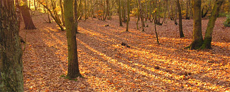
Autumn colours at Royden Park - Dave Kenyon
Caldy Hill, Thurstaston Hill and Royden Park:
These are extensive areas of heath and woodland excellent for walking and birdwatching, with good views of the Estuary. There is a network of paths connecting them to each other and to the shore.
The River Dee:
Starting from the Old Queensferry Bridge there are walks along the River Dee going both towards the Estuary and all the way to Chester.
Wepre Wood, Connah's Quay:
An area of woodland and streams with an old ruined castle. Makes a very pleasant walk in Spring or Summer.
Flint Castle and Marsh:
Going north from the Castle a path skirts a headland giving excellent views of the Estuary. Heading south past the Lifeboat Station a track leads over a low sea wall with a close up of a high tide roost on the marsh.
Bagillt Marsh:
The path starts 1/4 mile north of Flint on the A548 just before a business park on the right. Go across the railway through a marsh and onto a seawall overlooking the Estuary. Turn north to walk along the seawall as far as Bagillt where a footbridge takes you back over the railway to rejoin the A548.
Greenfield Seawall:
A path runs along the seawall from the north end of Bagillt to just south of Mostyn Quay. Best access is from Greenfield where the ship, the Duke of Lancaster, is docked (you can't miss it!).
Greenfield Valley Park:
An area of extensive woodland, an old Abbey, museum, 'urban' farm, three small reservoirs and overgrown derelict industrial buildings. The park stretches from the A548 coastal road up to Holywell.
Garth Woods and surrounding area:
Located just inland from Ffynnongroyw
this wood is one of the most pleasant woodland walks along the coast. The
woodland contains a diversity of birds, plants and trees and is owned by
the Woodland Trust.
A look at the Ordnance Survey map of the area reveals a whole network of
paths in the hills behind Mostyn and Ffynnongroyw, well worth exploring
with some marvellous views of the Estuary.
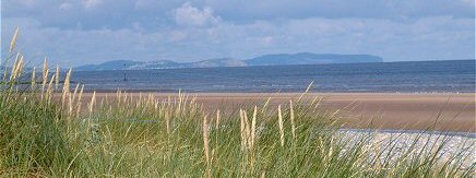
Gronant Sand Dunes and Beach - Richard Smith
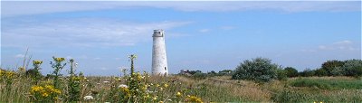
Point of Ayr, Talacre Warren/Sand dunes and Gronant:
From the road access walk south along the
sea wall for 1/4 mile towards the hide at the RSPB reserve.
Going the other way towards the Lighthouse brings you out on a golden
sandy beach. Walk along this beach for a pleasant walk to Prestatyn via
Gronant sand dunes, where the Little Terns nest.
An alternative route to Gronant is through Talacre Warren, a lovely area of
grassland and scrub behind the sand dunes - full of wildflowers,
butterflies and birds. The Gronant sand dunes and beach can also be
accessed from the end of Shore Road (next to Presthaven Caravan Park). In
the summer a leisurely stroll around the outer fence of the Little Tern
Colony can take a good hour, but please keep away from the fence to avoid
disturbing the Little Terns.