Map of Hoylake and Red Rocks (Scale: Approx 2 miles across)
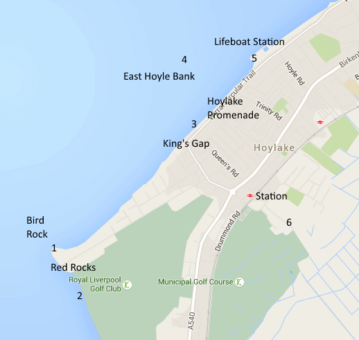
Directions: Approaching
Hoylake from the Liverpool/ Birkenhead direction on the A553 proceed
straight through the main shopping area (Market Street) until you come
to the "Knot" roundabout . Turn right along Kings Gap Road. First left
is Stanley
Road leading to Red Rocks with views over the sea to the right (1) and
Red Rocks Nature Reserve to the left (2), straight on takes you to
Hoylake
Promenade (North Parade), the beach (3) and sand banks (4). The
Lifeboat Station and ajacent grassy area is a good viewpoint and
affords some shelter from a westerly gale (5). There is
parking both on Stanley Road and the Promenade. Hoylake has good train
and bus links with both Liverpool and Birkenhead. Map Refs: Red Rocks
SJ 202886, Hoylake Shore (West End) SJ 213893.
To the
south of the railway station is
a path leading to Gilroy road in West Kirby (6). This takes you past both
the
Langfields and Gilroy pool. The path can be accessed from the end of
New Hall
lane (off Carr lane) which takes you through New Hall farm yard - a bit
muddy,
or you can get to it from Gilroy road West Kirby. The path is tarmaced
and
usually dry.